Say hello to the transformed UDOT Traffic
Welcome to UDOT Traffic
Get started to discover new and exciting features!
Signing up with UDOT Traffic
- Creating an account is NOT mandatory on this website; however if you do, you’ll be able to personalize your experience and receive traffic alerts.
- Select ‘Sign Up’ from the menu options in the top right corner
- Enter your name, email, and create a password. Click ‘Sign Up' when done.
- You will get an email to verify your account, click the link that was sent to your email.
- Including a phone number will allow you to receive text alerts, you will receive an SMS (text) with your confirmation code. Note this is in addition to the email verification.
Creating & Saving a Customized Route
- Enter your start and end locations by typing the addresses into the address fields. Alternatively, you may also right click on the map. Once you have entered the route locations, click ‘Drive’
.
- Review the routes generated and select the one that suits you best.
- When done, enter a name for your route and click ‘Save’.
Creating an Alert for your Route
- Once your route is saved, you will be asked if you want to be notified of events on this route. Click ‘Create Route Notification’
- You will be redirected to the alert creation page. Enter the required information for your route, select a delivery option (email or SMS), and click ‘Save’.
- You will now be notified of any future events that affect your route.
Welcome to Utah Traffic
Get started to discover new and exciting features!
Signing up with Utah Traffic
- Select ‘Sign Up’ from the menu options in the top right corner
- Enter your name, email, and create a password. Click ‘Sign Up' when done.
- Verify your account by following the link that was sent to your email.
- If you registered with a phone number, you will also receive an SMS (text) with your confirmation code
Creating & Saving a Customized Route
- Enter your start and end locations by typing the addresses into the address fields. Alternatively, you may also right click on the map, select a location from the available options, and select whether the location will be the start or end of your trip. Once you have entered the route locations, click ‘Drive’
.
- Review the routes generated and select the one that suits you best.
- When done, enter a name for your route and click ‘Save’.
Creating an Alert for your Route
- In the Manage My Routes table, find the route that you previously saved that you would like to create an alert for and click ‘Create Alert’.
- You will be redirected to the alert creation page. Enter the required information for your route, select a delivery option (email or SMS), and click ‘Save’.
- You will now be notified of any future events that affect your route.
Road Weather Alert
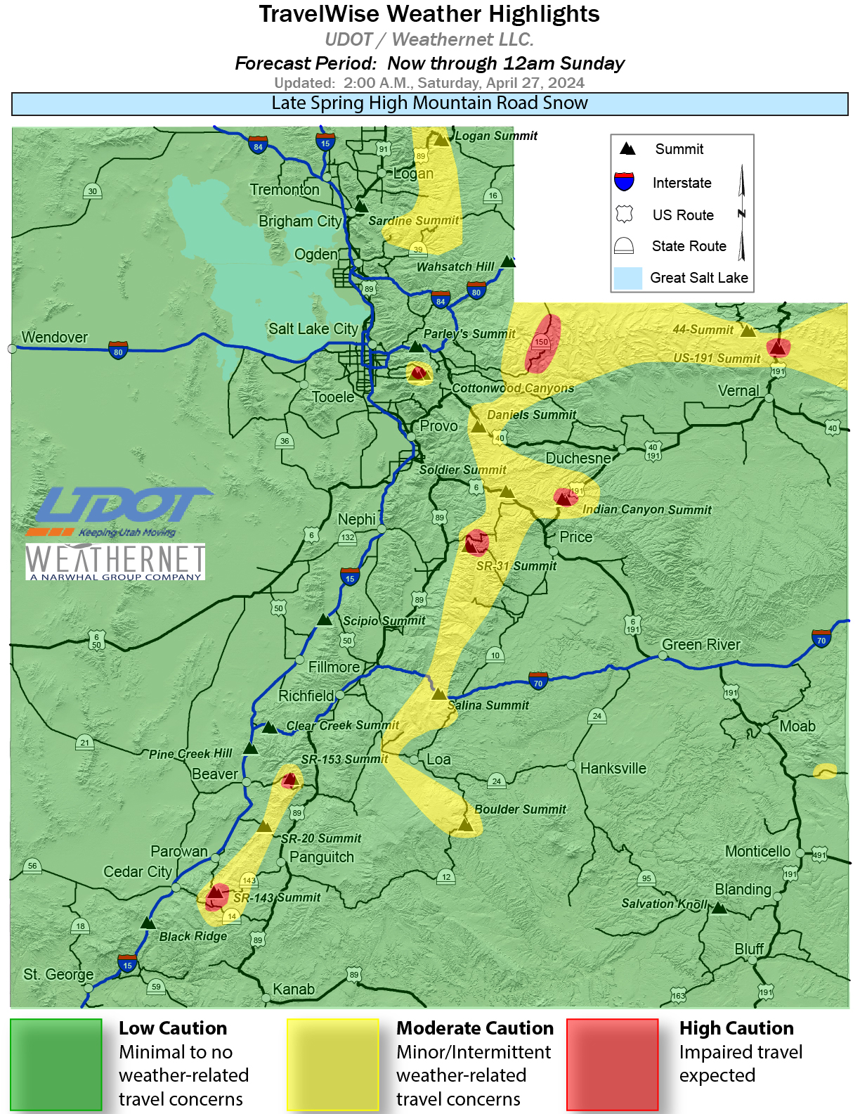
| Late Spring High Mountain Road Snow Forecast Period: Now through 12am Sunday
Text Updated: 2 AM Saturday, April 27th, 2024 Statewide rain/rain showers are expected to continue into Sunday morning with heavy rain at times along parts of the Wasatch Front. High mountain snowfall will continue through Saturday night before dissipating. Heavy road snow is expected above 9000’ with higher mountain ranges seeing over a foot of new snow. High passes/summits between 7500-9000’ will see periods of moderate road snow/slush through Saturday night. Some very brief slush ups are possible down to about 7000’, including Parleys Summit, by very late Friday night and into early Saturday morning. All routes below 7000’ will run wet with mostly rain falling over the next few days. Areas of standing/ponding water will be possible along lower elevation routes across the urban corridor mainly before Saturday afternooon. Drier and warmer weather moves back in beginning on Sunday. Motorists are advised to use caution and TravelWise. Motorists using canyon and mountain routes should be aware Traction Laws may be enforced. The following routes will experience weather-related travel concerns during the forecast period:
|
 |
**This document is intended to be a forecast of statewide storm impacts. For current roadway conditions and restrictions, refer back to the home page.**
Produced for UDOT by Weathernet LLC.
Produced for UDOT by Weathernet LLC.